European Alien Species Information Network - Web Services
EASIN Web Services
The RESTful Web Services enable users to query and retrieve species information from EASIN databases.
EASIN provides two Web Services: the Catalogue Web Service and the Geospatial Web Service.
Allows users to retrieve information from the EASIN Catalogue
in the form of JSON objects.
Users can retrieve records by species’ scientific name, environment, impact, taxonomy, Union concern status (LegalFramework) and more.
Guidelines
The root URL for all the Catalogue services call is https://alien.jrc.ec.europa.eu/apixg/catxg
A skip/take logic allows the retrieval of records in subsets, enabling the process when large numbers of records result from a specific query.
The following criteria can be applied to retrieve species information from the EASIN Catalogue:
List of all Species in the EASIN Catalogue
Single Species by EASIN Species ID
Replace the {easinid} with the actual EASIN Species ID.
Species Name (or part of it)
Replace the {term} with the scientific name of the species you are looking for, or part of it. The minimum number of characters to start the search is four.
Environment
Replace {environment} with one of these abbreviations: MAR, FRW, TER, EST to filter species by, marine, freshwater, terrestrial or oligohaline environments respectively.
Species of Union concern
The URL: https://alien.jrc.ec.europa.eu/apixg/catxg/euconcern retrieves all the species of Union concern (EU Regulation 1143/2014).
Species of Member State concern
Retrieves all the species of concern for the selected Member State(s).
Replace the {countrycodes} placeholder with the desired country code.
To retrieve species of concern to more than one Member State, simply concatenate country codes by using commas, i.e. 'AT,BE,BG'.
List of accepted country codes.
Species of Outermost regions concern
Retrieves all the species of concern for the selected Outermost region(s).
Replace the {regioncodes} placeholder with the desired outermost region code.
To retrieve species of concern to more than one Outermost region, simply concatenate region codes by using commas, i.e. 'FR7,PT2,PT3'.
List of accepted Outermost regions codes.
Impact
Replace the {impact} placeholder with “hi” to select high impact species, or “lo” to select low or unknown species impact.
Taxonomy (single level)
Replace {taxa} with Kingdom, Phylum, Class, Order or Family, and {taxa name} with the respective taxa names of interest.
Taxonomy (full)
Follows the same logic as for the 'single level taxonomy', by adding additional taxonomic levels and names to the search path.
Species presence in specific countries
Retrieves species present in specified Countries.
Replace the {countrycodes} placeholder with the desired country code, or concatenate country codes by commas, i.e. 'DK,EE,FI'.
List of country codes:
Species’ Status
Replace the {status} placeholder with 'A', 'C' or 'Q' to search for Alien, Cryptogenic or Questionable species respectively.
Horizon Scanning Species
Retrieves species added to the EASIN Catalogue based Horizon Scanning assessments.
Partly Native species
Use this criterion to search for species native in at least one Member State.
Species' Native range
Retrieves species for Countries in which they are native.
Replace the {countrycodes} placeholder with the desired country code, or concatenate more country codes by commas, i.e. 'DK,EE,FI'.
List of country codes:
This Web service is used to retrieve spatial information on species occurrences from the EASIN Geo Database in the form of Well Known Text (WKT) geometries contained in JSON objects.
The root URL for this service' endpoints is https://alien.jrc.ec.europa.eu/apixg/geoxg
A skip/take logic is used to obtain paginated results, improving the service performance and providing the users with a more usable output.
Users can retrieve geospatial information per single species selecting occurrences from a specific country and including or excluding specific EASIN Data Partners.
An interface is available to select the desired filters and compose the related URL accordingly.
The JSON format is intended to be used as a data transfer format, to enable machine-to-machine data transmission, or as a base format to download and transform to get data as a table.
There are several online tools available to users to convert or visualize JSON files in commonly used formats, e.g. CSV, Excel, table format. For instance:
Search example
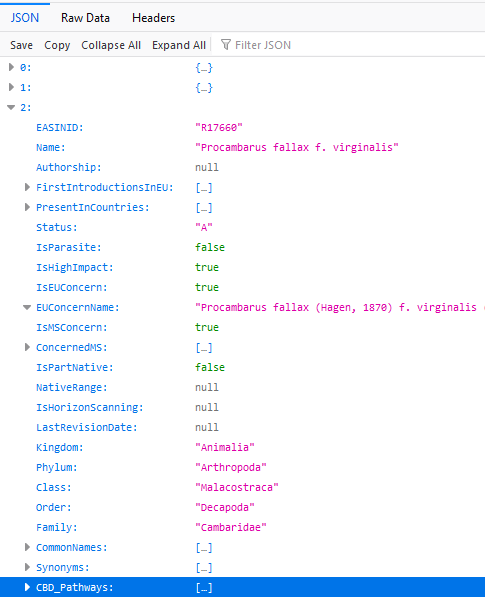
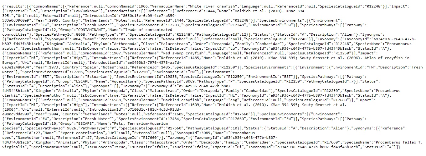
We want to retrieve information from the EASIN Catalogue, concerning crayfish species whose name contains 'Procambarus'.
1. Use the link https://alien.jrc.ec.europa.eu/apixg/catxg/term/Procambarus; press enter.
2. If executed in the Firefox web browser, the above query returns an output similar to figure 1, where the three (0 to 2) found species data appear collapsed except the last one. The web service output might be displayed unformatted as in Figure 2 if using a browser/software not formatting the output.
3. To convert and read the JSON output, please paste or load the JSON in one of the following online tools, or in tools/software you prefer: